
IT
rek Overview
Quick Facts
Maximum Altitude
12,100 ft.
Trek Duration
3 Night / 4 Days
Trek Distance
20 Km
Difficulty Level
Easy to Moderate
Start/End Point
Prince Chowk, Dehradun
Nearest Airport
Jollygrant Airport, Dehradun
Best Season
All year except (Monsoon)
Accommodation
At Raithal Guesthouse
Meals
Breakfast, lunch, evening snacks & dinner
Permits
Forest Department & Trekking permit
Temperature
10°C to 18°C (daytime) - 5°C to 5°C (nighttime)
Snow
December to February
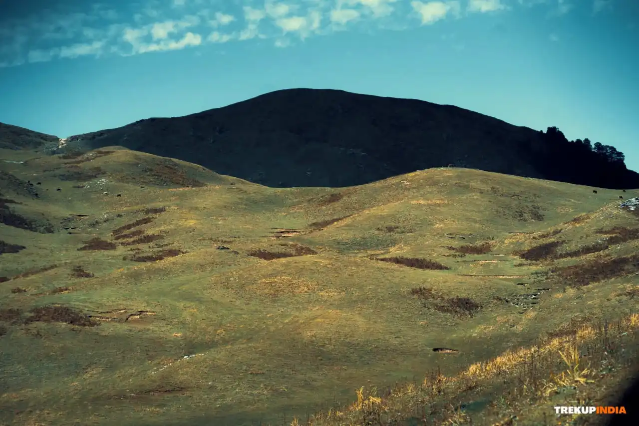
Dayara Bugyal is one of the most spectacular treks in India that offers a fabulous combination of easy access and some of the most expansive countryside views of the Himalayas. The trek starts at Raithal, which is approximately 7,400 feet above sea level. The first part of the trek will take you through dense forests filled with red rhododendrons and oak trees. As you reach Dayara Bugyal you will see a huge, undulating expanse of alpine meadows that span approximately 28 square kilometers. Dayara Bugyal is shaped like a natural amphitheater with clear views of the huge peaks surrounding the meadows (Mt. Bandarpoonch, Kala Nag (Black Peak), Draupadi ka Danda, and the entire Gangotri range). The versatility of Dayara Bugyal throughout the year is exceptional. In the spring months, it is filled with bright colours and wildflowers; in summer, a thick, emerald green blanket of vegetation; and during winter it will be a skier's paradise with deep snow covering the slopes. The gradual slope commencing from Raithal and extending over 4–5 days (a total of about 20 km) makes this trek an ideal choice for families, beginners or photographers interested in capturing a true Himalayan scene.
Why is the Dayara Bugyal Trek so special?
The geographical and cultural aspects of the Dayara Bugyal trek set it apart from other Himalayan Trails, and there are several specific metrics that demonstrate the uniqueness of the Dayara Bugyal trek as compared to the majority of other trails in this area. This trek is much more than a trek; it’s a unique experience that offers trekkers the opportunity to experience an ancient seismic landform and a unique sub-alpine ecosystem.
1. The Sky Plateau, Geomorphology
Most of the Himalayan meadows are fairly confined by narrow ridgelines and limited open areas while Dayara is a large undulating table land covering an area of approximately 28 square kilometers (70,000 acres).
- The Infinity Effect: With a mean elevation of 11,500 feet, the topography of the plateau consists of extensive rolling hills which obscure the depth of the valleys below.
- Spatial Scale: The combination of these characteristics provides a psychological infinity effect whereby one feels as though they are walking across an endless ocean of green (or tundra) that has become separated from the earth, thus providing a scale of which one does not have the experience of often along typical trekking routes.
2. The Zero Obstruction Panorama
The way the plateau has been oriented to face the Greater Himalayan Axis makes the absence of interfering ridges from which to obstruct views very important.
- Vertical Relief: From the foot of the meadow to the peak of Mt. Bandarpoonch (20,721 feet) there is a total of 8,000 feet of vertical relief visible at once.
- Peak Visibility: The 180-degree arc offers the highest density of giant peaks: Kala Nag (or Black Peak) and Mt. Srikanth and the Gangotri I, II and III massif are all seen as being very close together from vantage points.
3. Koti Banal: Seismic Skyscrapers (Heritage)
Located at Raithal, the trek base, Koti Banal architecture is one of the most prominent examples of an ancient style of seismic-proof construction that has been around for over 900 years.
- Structural Engineering: One example of Koti Banal construction is Panchpura Bhawan, a dharamshalla built using alternating layers of Deodar logs and dry stone concrete blocks.
- Seismic Resilience: The special crib-log construction method makes five-storey structures flexible, enabling them to dissipate energy from earthquakes and survive without collapsing. Every major tectonic event has occurred since at least the 16th century, and Koti Banal buildings have been able to withstand them all due to this construction method.
4. The Anduri Biocultural Event (Tradition)
Located within Dayara, the Anduri Utsav is celebrated every August 17th as a "Butter Holi."
- Pastoral Ritual: Resident shepherds and villagers come together to express gratitude for the meadows, which have provided verdant pasture lands for grazing animals.
- Resource Density: Over 500 kg of fresh milk and butter is ritualistically used during the festival. This festival is regarded as one of the most exceptional examples of a highland agricultural festival that incorporates creativity and spirituality in light of the successes of agriculture.
5. Natural backcountry ski lines (Winter Physics)
Dayara is very much a season-specific location for skiing and snowshoeing activities in the winter months of October through February.
- Fall Line: The meadows here have an approximately consistent gradient of 15-25 degrees (15-25%) over the distance of 3 kilometres. Hence, Dayara has a natural fall line for downhill skiing.
- Dry Powder: Dayara is situated at a relatively high elevation, making it a great place to get dry powder (i.e., dry, crystalline snow), a snow type that is very desirable by professional skiers while generally uncommon for resorts located below 3,000 meters.
Trek Highlights

Scenic Beauty and Landscapes
One of the most defining features of this trek is the massive and mysterious Sky Plateau, a flat expanse that sits 28 km (over 7,000 acres) in the heart of the Himalayas.
- The Infinity Effect: Perfectly situated at 11,500 ft along the southern slopes of Dayara, the vast expanse of grassy knolls hides the steep cliffs surrounding this particular area. Making it feel like you have entered a vast expanse of green (or white) tundra, separated from all reality.
- Orography: At the same time, the Sky Plateau gives you a unique opportunity to experience an unbelievable 8,000 feet of vertical relief between its elevation and the top ridge of the Bandarpoonch before you.

Summit Experience
The focus of this trek is the meadows, however they have a destination and will culminate in reaching Dayara Top at 12,100 ft. dayara top is often followed up with visiting Bakariya Top which is a bit higher at 12,400 ft., to be able to take in a full 360-degree experience available.
- Ridge Walk: On the last leg of the trek, the main challenge you will face is the narrow ridge to walk along as you will be looking directly down and out over the Bhagirathi Valley on one side.
- Panoramic Reach: You will have the ability to see the widest view possible from the highest point of this trek. In addition to having an excellent view of the mountain you stood on, you will also be able to see a 180-degree arc of the landscape all around you as well as a view of the surrounding mountain range including Kala Nag (Black Peak), Mt. Srikanth, Draupadi Ka Danda, Gangotri I/II/III range.

Best Season & Seasonal Beauty
- Summer - May/June = Emerald phase: During the summer the meadows will be green and lush, the meadows will have colourful wildflowers such as Primula and Potentilla covering most of the area.
- Autumn - September/October = High Definition phase: After the monsoon there will be no atmospheric dust on the air which makes it easier for an individual to photograph from a distance and have clear, easier to view pictures.
- Winter - December/February = Arctic phase: The plateau will be completely white due to snow covering everything that existed there during the summer and fall. This location will be a great area to snowshoe and will have dry powder snow and enough snow to enjoy a winter wonderland.

Cultural & Village Life
The trek starts in Raithal, which has a history of Koti Banal—an ancient engineering style that dates back over 900 years—and living examples of this style can be found in Raithal.
- Seismic Skyscrapers: You will come across 5-story houses, many of which are over 500 years old, built using alternating layers of deodar timber and dry stone bricks or concrete. Because of the flexibility of their design, the buildings can sway during earthquakes rather than collapse under the stress of seismic activity.
- Butter Festival: If you are here in August, you will be able to partake in the Anduri Utsav, which is a celebration for the "Butter Holi" ritual in which many hundreds of kilograms of milk and butter are smeared on each other across meadows by the local villagers as a demonstration of gratitude to their Creator.

Flora & Fauna
Each time you trek up 1,000 feet on Dayara Bugyal, a different Biological World is revealed to you through an ecological transition, or altitudinal zonation. The Dayara Bugyal trek is a vertical laboratory that offers you the opportunity to walk through multiple ecosystems over a period of only several days of trekking.
- The diversity and zonation of forests: The trail traverses through the dense Oak and Maple forests at lower elevations; which changes into a vibrant Rhododendron zone that creates an astonishing crimson canopy every March-April.
- The change to timberline: Upon crossing 11,000 feet, all of the trees will have disappeared and the area will be dominated by large alpine meadows (Bugyals) covered with thousands of Primulas, Potentillas and various medicinal plants in the summer months.
- The Himalayan Monal: The trek provides some of the most concentrated habitats for the Himalayan Monal (Uttarakhand's state bird), which can be recognised by the many colours of its iridescent plumage.
- Wildlife hotspots: The areas surrounding water bodies, such as Barnala Tal provide excellent opportunities to view animals like the Himalayan Red Fox, Barking Deer, and occasionally the Musk Deer during the dawn or dusk hours.
- High Elevation Birds of Prey: The open skies of the plateau are filled with the mighty Golden Eagle and Bearded Vultures, who take advantage of the thermals created by the mountain range to soar high above the ground.

Adventure and Difficulty Level
The Dayara Bugyal trek has been classified as an Easy to Moderate trek, as it provides trekkers with a high reward for low effort. Its slope profile is beginner friendly.
- Effort to Reward Ratio: Rated Easy to Moderate. The Trek offers, essentially without exertion, one of the most beautiful views of the Himalayas. Beginners have an increase of roughly 1 vertical meter per 10 meters walked. Physical trekking is reasonably easy and can be accomplished by most people.
- The Cold Sink Effect: The greatest difficulty of this trek is the topography of the plateau, which acts as a basin for freezing, heavy air that gets extreme drops in winter temperatures. Because of the accumulation of cold air in the Camping areas, at night, the temperature could reach -12 degrees Celsius or less. Oxygen is available at 70%. Because of the decreasing atmospheric pressure, you only have access to 70% of the Oxygen at sea level.
- Focus on Thermal Control: With very low physical effort but a high degree of environmental intensity, the real adventure and challenge is to control your heat very carefully and to properly adapt your body to the conditions found.

Unique Experiences
- Effortless Impact: Trekking safely to an incredible 20,000 is easy with the generous 1:10 incline that gives you access to all of that view without the twisting and turning associated with vertical trekking.
- Mirror Point Lakes: The pristine bodies of water tucked away in Gui and Barnala both offer perfect 1:1 reflections of the Grand Himalayan Peaks.
- Monal Sanctuary: Terrestrial views of the magnificent colour displays created by the Himalayan Monal provide these flying rainbows against the white snow background.
Short and Detailed Itinerary, Trek Map and Altitude Chart of Dayara Bugyal Trek
This section gives you a complete and easy-to-understand breakdown of the Dayara Bugyal Trek, from day-wise route planning to altitude gain and campsite details. The short itinerary helps you quickly understand the trek flow, while the detailed itinerary provides in-depth information about daily walking distance, terrain type, campsites, and acclimatization.
Along with the itinerary, the trek map shows the exact trail route, villages, forests, and campsite locations, helping you visualize your journey through snow-covered pine forests and alpine meadows. The altitude chart clearly displays height gain and loss each day, ensuring better preparation, safer acclimatization, and a smoother trekking experience.
Together, these tools help you plan confidently, understand the trek difficulty, and prepare physically and mentally for the Dayara summit climb.
IS
hort Itinerary
Day 1:Drive from Dehradun (1,500 ft.) to Raithal (7,100 ft.)
Drive Distance
184 Km (8 - 9 hrs)Altitude Gain
5,600 ft.Meals
Evening snacks and dinnerStay
At Raithal GuesthouseExpert Advise: If you have motion sickness problem make sure to take medication prior to the drive starts.
Day 2:Trek from Raithal (7,100 ft.) to Gui (9,500 ft.)
Trek Distance
4 - 4.5 Km ( 4 - 5 hrs)Altitude Gain
2,400 ft. Meals
Breakfast at Raithal, lunch, evening snacks and dinner (Gui).Stay
At Gui campsiteWater Sources: Carry your water bottles filled from Raithal campsite
Day 3:Trek from Gui (9,500 ft.) to Dayara Bugyal top (12,100 ft.) & back to the Gui campsite (9,500 ft.)
Trek Distance
10 Km ( Both sides) - 8 hrsAltitude Gain
2,600 ft.Meals
Early Breakfast, packed lunch, evening snacks and dinnerStay
At Gui campsiteWater Sources: Fill your 2L thermos flask from Gui campsite
Day 4:Trek from Gui (9,500 ft.) to Raithal (7,100 ft.) & drive back to Dehradun (1,500 ft.)
Trek Distance
4 - 4.5 Km (4 - 5 hrs)Drive Distance
184 Km (8 - 9 hrs)Altitude Loss
2,400 ft. Meals
Breakfast at Gui & lunch at RaithalStay
Reach by 8 - 9 Pm at nightWater Sources: Fill your 2L thermos flask from Raithal
Dayara Bugyal Trek Route Map and Altitude Chart
Trek Map
We’ve prepared a comprehensive Trek Route Map for your upcoming adventure to Dayara Bugyal, designed to give you a clear understanding of the entire journey, from the starting point to the summit and back. This map highlights all major stops, trails, elevation points, and landmarks along the route. It also includes detailed information about the terrain, distance between campsites, and estimated travel times, helping you plan your trek efficiently and stay well-prepared throughout. Each detail has been carefully curated to ensure you have all the essential information at your fingertips for a smooth and safe trekking experience. We recommend reviewing the route map thoroughly before your trek. If you have any questions or need further clarification, feel free to reach out to our Trekup India support team, we’re always here to help you prepare for your journey with confidence.

Altitude Chart
Dayara Bugyal Trek Altitude Chart is a valuable reference for trekkers to track altitude changes throughout the journey. It helps you understand the elevation gain at each stage of the trek, plan your pace effectively, and monitor your body’s response to higher altitudes. This chart is especially useful for both first-time trekkers and experienced adventurers, as it allows you to prepare better, manage acclimatization, and make the most of your Himalayan experience. By referring to the altitude chart, trekkers can visualize the gradual ascent and descent of the trail, ensuring a safe and well-paced trekking journey.

ID
etailed Day Wise Dayara Bugyal Trek Itinerary
Day 1: Drive from Dehradun (1,500 ft.) to Raithal (7,100 ft.)


Basic details for the day: The first day of the trek journey takes from Dehradun to Raithal. The distance is a little over 185 km and the time taken will be approximately 7- 8 hours. Starting at an elevation of 1,466 ft, one must trek to an approximate elevation of 7,100 ft. This is quite a large increase and can put a lot of stress on your body, so it is important that you stay hydrated and keep your body moving to help with the acclimation process. The route will take you through Mussoorie and the stunning Bhagirathi River valley. Upon arriving at Raithal, you are welcomed with the evening snacks and hot delicious dinner at night. Remember, Raithal is the last reliable source of electricity or mobile phone service before plunging into the wilderness.
Route Description and Terrain Insights: You will travel through some amazing geographic features of the Himalayas. You will come down from the flatlands of the Doon Valley to the lower elevations of the Himalayas, then back up again over the next 10-15 minutes to a higher viewing point overlooking the valley and the Lake Tehri Dam area. This section is where you will begin to experience the very rugged terrain leading into the Bhagirathi River. The road in this area is overall well maintained and has many very steep turns; it is essential to have a strong stamina while navigating these curves.
Natural and Scenic Highlights: While you are on the road most of the way, the Bhagirathi River is one of the biggest highlights of your travel route. Its turquoise-colored water contrasts with the steep rugged cliffs lining its banks. You will travel through lush green pine forests and terraced apple orchards that are part of your ride through the Uttarkashi district. When you drive the last series of switchbacks up to Raithal, you will be greeted with spectacular views of the massive snow-covered peaks of the Gangotri Massif and Mt. Shrikanth when they become ablaze in golden hues at sunset.
Cultural and Local Touchpoints: The first stop along the way will be at Uttarkashi, which is referred to as the Kashi of the North. This town has been populated since before the time of the Vedas. When you reach Raithal, you will be introduced to a distinct architectural style, called Panchpura architecture. This village is one of the few that still have preserved fully intact, wooden houses that are over 500 years old and built using earthquake-resistant methods. The beautifully carved wooden structures are considered a living example of Garhwali culture and are great examples of ancient architecture.
Safety and Acclimatization Guidelines: Trekking 5,600 feet in just one day is a huge physiological change for your heart and lungs. To keep yourself safe, you must keep yourself hydrated by drinking small amounts of water throughout the entire length of your drive. You should also avoid the urge to sleep on the way up; it is beneficial for you to remain awake because your breathing pattern will remain consistent with the altitude gain.
Experience Notes by our trekkers who completed this trek: Raithal is known as a model village checked out for the sustainable tourism industry, where the people are more than just hosts, as they also think of themselves as the protectors of the mountain. You will also discover local farming and sheep herding within the confines of the town. One of the major highlights of the People Experience is the opportunity to enjoy a cup of salt tea (Cha-Sya) while listening to the elders recount stories about the ancient traditions surrounding the Anduri Utsav (Butter Festival).
Camp Information & Logistics: You will spend the evening at a traditional village homestay instead of the tent, as this provides better insulation than a camping tent or tarpaulin due to the solid wood walls of the village homestay. The traditional village homestay is your last chance to have electricity and mobile coverage (Jio/BSNL) before continuing on your trek. The dinner will typically consist of an organic feast consisting of Gehat Dal and Mandua ki Roti.
Practical tips for trekkers: Carry ginger candy or motion sickness medicine to help with the non-stop twists and turns of the Suwakholi road, charge all of your power banks and batteries all the way before you begin your journey as the low temperatures in the higher altitudes will quickly deplete the power of your equipment, and do a final supply check while in Uttarkashi to grab any necessary items such as ponchos or energizing snacks before you leave behind any form of commercial access.
Dayara Bugyal Trek Photos and Videos
This section showcases real moments from the Dayara Bugyal Trek captured on the trail, from snow-covered forests and glowing summit views to campsite life and trekking experiences. Through authentic photos and videos, you can visually explore the journey, understand the terrain, and feel the adventure before you go.
IP
hotos


IV
ideos

Dayara Bugyal Trek Reviews and Experiences
IVideo Reviews
Real trekker reviews and personal experiences give you a true picture of what the Dayara Bugyal Trek feels like on the trail. In this section, trekkers share their honest feedback about snow conditions, campsites, food quality, safety arrangements, trek leaders, and overall experience with Trekup India.
These stories help you understand the actual trekking atmosphere, how challenging the summit climb feels, how magical the sunrise views are, and how well the team supports beginners. Reading real experiences builds trust, answers common doubts, and helps you confidently plan your Dayara Bugyal adventure with Trekup India.


Best time for Dayara Bugyal Trek: Season by season guide
Dayara Bugyal is a unique and special trek in the Himalayas, as it provides stunning views throughout the year, with a variety of terrains and climates that are ideal for families and beginners from April to June, when the meadows come alive with Rhododendrons blooming. In addition, due to increased air clarity and the opportunity to take great pictures, September through November is an optimal time for perennial trekkers and photographers, as they will be able to see the snow-capped peaks that are over 20,000 feet high and the meadows will turn into gold and brown. Finally, December through February is a great time for adventurous skiers and people who love the outdoors because the plateau becomes a white desert with 3 to 5 feet of snow covering it and creates an ideal opportunity for adventure seekers to test their physical limits in a quiet high alpine area with sub-zero temperatures.
Dayara Bugyal Trek: Month by Month Breakdown
Here is the month by month breakdown for Dayara Bugyal Trek categorized by the seasonal transitions and expected trail conditions.
Advice by our Expert Team
Our Expert trek leaders and trek guides are well known about the trekking trails with the adverse weather conditions at higher altitudes and they know how to deal if any uncertainty arises. They have years of experience in trekking adventure and suggest you with some advice for the trek.
1. Prioritize Acclimatization: Stable weather in the spring and autumn makes it easier but never rush to the trek. There is a chance of AMS problems occurring due to dry cold so be prepared, take precautionary measures with yourself.
2. Proper Layering: Temperature fluctuates instantly, especially on the higher altitude, so layering should be proper (base, mid and outer) is critical for managing sweat and preventing the cold.
3. Premium Boots: Make sure your boots are long lasting and well broken or used before your trek starts. The risk of foot injury and blister from the new boot can end your trek journey
4. Hydration: It's advisable to drink 3 to 4litre/day. Because of high elevation and exertion, you need constant intake of fluids to overcome the effects from AMS.
5. Pace Yourself: Walk at a comfortable pace using what is called the mountaineers shuffle. This will conserve your energy and help you manage your breathing.
6. Protect Against UV Rays: Use High-Quality UV Sunglasses (Category 3 or 4) to protect your eyes from snow blindness, and use high SPF Sunscreen on your skin to protect it from sun damage.
7. Healthy Consumption: Food should consist of small amounts consumed frequently and contain a lot of nutritious ingredients and minerals. This will provide you with the sustained energy needed for trekking at high altitudes.
8. Safety: Pay attention to what your body is telling you when you are feeling AMS Symptoms. Should you believe you might be suffering from AMS, report it immediately and prepare to descend. Descending is the quickest treatment you can receive.
How to Plan Your Travel for Dayara Bugyal Trek
Are you excited to start your adventure for Dayara Bugyal Trek? The travel journey starts from Dehradun where all the trekkers reach & move towards Raithal. In this section we will guide you how to plan & proceed your travel journey for Dayara Bugyal Trek. From your home town to pickup point Dehradun, we guide you with all the necessary means of transport for a smooth and adventurous journey. You can opt various means of transport like flight, train & bus to reach your pickup point at Dehradun.
Modes of transport To Reach Dehradun (The base pickup City)
There are various means of transport to reach at your pickup point via flight, train & bus with variation in timings. All the flights, trains & buses have different arrival & departure times so plan your travel journey. We have mentioned all the information regarding the travel perspective for your convenience.
1. By Flight (Fastest Means)
The Jollygrant Airport is located 30 km away from the pickup point. There are scheduled, nonstop flights from all major metro cities such as Delhi (DEL), Mumbai (BOM), and Bangalore (BLR) etc.These airlines offer direct flights from multiple cities.The timings are subject to change and will vary day by day. You can book your flight one day prior to your travel journey.
Suggestions: Please make sure to arrive early, if you have enough time for your journey you can rent a room at an affordable price in nearby Prince Chowk, Dehradun.
2. By Train (Dependable Means)
The railway station of Dehradun is very close approximately 500-600 Meters from the pickup point. You can cover the distance by walking to the pickup point. The best train services for overnight travel from Delhi (New Delhi Railway Station) to Dehradun:
Suggessions: Ensure to book AC's or Sleeper seats in advance of your travel during peak winter season.
3. By Bus (Affordable Option)
The ISBT of Dehradun is 5.7 km away from the Prince Chowk, Dehradun. Buses are well air-conditioned like Volvo, Sleeper, and Non-AC buses with departures mainly from Delhi, Jaipur, Mumbai, Bangalore and other cities. The timings are subject to change and will vary day by day.
Buses from ISBT Kashmiri gate Delhi to Dehradun runs on a frequent basis starting from early midnight 12:00 and taking (5-7 hrs) to reach Dehradun through Redbus, MakeMyTrip,Goibibo and other UTC buses. Now the timings are quite short because there is an open highway which might take 1-2 hrs short as compared to the normal route. After reaching the ISBT Dehradun, you have many options like auto, cab or tempo to reach Prince Chowk, Dehradun.
Suggestions: Consider using an overnight air-conditioned Volvo/ac sleeper bus service to reach early morning (5.00 am to 6:00 am).
How to reach trek base Raithal from pickup point Dehradun
From Dehradun, it is approximately 184 Km and takes 8 - 9 hours by road. While travelling from Dehradun to Raithal you will cross Mussoorie, in Suwakholi we will halt here for around 30 minutes for breakfast, after Suwakholi you will drive along a river with the scenic beauty of Chinyalisour. After Chinyalisour we will reach Dharasu - Uttarkashi where we will halt for Lunch with a scenic Gangotri valley view. After having lunch you will head towards Raithal. On the way we will cross Bhatwadi and from Bhatwadi drive will be along the Yamuna river.
Means of transport from Base city Dehradun to Campsite Raithal
1. Trekup India Vehicle: If you book with the Trekup India, transportation depends on the number of trekkers according to their size, vehicles will differ like tempo traveler, bolero, innova or mini bus. Our cab picks you from Prince Chowk, Dehradun & drops you at Basecamp Raithal safely. Our vehicles are well maintained & hygienic for your travel journey.
Here are the pickup details from the base city Dehradun (If you opt our transport facility):
- Pickup Point: Prince Chowk (Near Railway Station, Dehradun)
- Pickup Time: 6:30 AM
- Drop Location on Last Day: Prince Chowk (Near Railway Station, Dehradun)
- Drop Time for Last Day: 08:00 PM - 09:00 PM (expected)
2. Public Transport Bus: You can opt for a public transport bus early in the morning to reach base camp Raithal on time for the next day's trek. But make sure you are particular with the bus time in the morning as there are very limited buses between 5:30 AM to 7:30 AM. There is no bus after this so try to pick a bus early from Dehradun.
3. Private Taxi/Cab: If you miss your bus from Dehradun, another way to reach Raithal is by taxi/cab. You can book a taxi/cab on a sharing basis with a shared price. But make sure that your timing is matched with the taxi timing as the number of taxis are very limited in the morning and generally operated early in the morning from 5:00 AM onwards.
Tips for Mountain Drive
Whenever you are planning to trek on the mountains, health plays a crucial role. Your main motive on any trek is to be physically and mentally healthy. Here are all the important travel suggestions that you are going to face on your travel journey.
- Motion Sickness: Take medication Dimenhydrinate (prescribed by doctor) - 30 minutes before your journey starts and make sure to sit in the front seat of the taxi.
- Punctuality: Being a wise person, always be on the time whether you are on the camp site or on the trek.
- Inhand Case: Have an adequate amount of cash because you never find any ATM . at a nearby location.
- Proper Hydration: Always take the water and fruits throughout your travel to avoid dehydration & other health related issues.
- Charge: Make sure that all electronics / power banks are fully charged before being stuck in a long taxi ride, as there are not many charging stations available on the route.
- Check luggage: always make sure to check your luggage when you are on the trek or during the trek.
Day 2 - Day 5 (The Trek Days)
After reaching the basecamp Raithal on Day 1, it's time to move towards the trek which starts from Day 2, trekking from base camp Raithal to Gui with 4 to 4.5 Km completed in 4 - 5 hrs after that there are some activities & hot meal for all the trekkers on the Gui campsite. On Day 3 from Gui to Dayara Bugyal Top and come back to Gui on the same day by covering a distance of 10 Km in 8 hrs approx. On day 4 at Gui campsite, after having breakfast our trek starts to Raithal with a distance of 4 - 4.5 km covered in 4 hrs and after reaching to the basecamp Raithal you will enjoy your delicious lunch there and certificate will be given to all the trekker by our trek leader and finally it's time to go back to Dehradun and it will take 8 - 9 hrs to reach there by covering 184 Km at night.
Planning Your Return Journey from Raithal to Dehradun
Once you have completed the Dayara Bugyal Trek, returning should be overwhelming with good memories, pictures and new friends on the trek. Our Trekup India vehicle will pick you from the base camp Raithal and leave you at the dropping point Prince Chowk, Dehradun. If you have already opted for transport with us.
Suggestions: Book your return transport after 09.00 P.M & for security you should also keep a buffer of 1-2 hours for your return journey in case there might be delayed due to traffic, land slides or vehicle breakdown.
Return From Dehradun to your Hometown
We have mentioned details of various means of transport like flight, train and bus with the estimated timings, so book accordingly with your preferred time. Below mentioned data helps you to choose and book for your return journey. Note: The timings are subject to change and will vary day by day. Also the mentioned timing is written in 24 hours format.
By Flight / By Train There are a number of flights and trains departing from Delhi to various designated cities on time. On the whole, you can book your flight or train from Delhi as there are many availability of flights and trains directly to your hometown. Suggestion: Try to travel by bus to Delhi and in Delhi you can further book your train/ flight to your hometown.
By Bus Here is the list of buses departing from Dehradun to Delhi with their departure and estimated arrival timings. Make sure you book your further travel after reaching Delhi according to the below mentioned time.
Safety Aspects and Emergency Exit for Dayara Bugyal Trek
1. Understanding Trek Safety
Your trek leaders and trek guide have years of experience in getting you to the summit but most importantly back to safety. Trekking at high-altitude requires a huge amount of respect for the mountains and therefore is a correct, safe way of doing things throughout, especially on a moderately challenging trek like Dayara Bugyal Trek. This responsibility starts with full understanding of Acute Mountain Sickness (AMS) prevention, a strict adherence to the gradual ascent plan, and absolute understanding of emergency procedures. Your ability to follow safety procedures will determine the success and enjoyment of the trek.
2. Acute Mountain Sickness (AMS)
Altitude sickness (Acute Mountain Sickness or AMS) is the result of the body being unable to adapt lower levels of oxygen pressure (*hypoxia*) at high altitudes (usually over 8,000 feet). The risk is that untreated AMS will progress to High Altitude Encephalopathy (HACE) or High Altitude Pulmonary Edema (HAPE) if the person keeps trekking higher in a state of unequipped acclimatization.
Important Symptoms of the Acute Mountain Sickness (AMS):
Mild AMS:
- Headaches are the most significant and common sign.
- Nauseous feeling, lack of desire to eat, and general tiredness.
- Poor sleep (insomnia).
Severe AMS (HACE warnings):
- Difficulty balancing and walking straight (unable to walk a straight line - "heel-to-toe" test).
- On-going severe headache that can't be helped with medication.
- Confusion or some alteration in understanding.
Severe AMS (HAPE warnings):
- Unable to breathe without feeling short of breath.
- Persistent cough with wet/sputum or sometimes pinkish-tinted frothy mucus.
- Excessive tiredness and feeling of heavy pressure in the chest area.
Precautionary Measures of AMS
1. Ascent Gradual
- The 4-day itinerary from Raithal to the Dayara Bugyal Summit point has been set up to allow for acclimatisation. You are advised not to skip camps and rush up the mountain.
- The principle of "Trekking High and Staying Low" at the Base Camp helps you get acclimatised.
2. Hydration and Nutrition
- You need to drink 3-4 litres of water every day. If you become dehydrated, it will only make any AMS (Acute Mountain Sickness) symptoms worse.
- You should continue to drink a lot of water, even when you don't feel thirsty. At the campsite, you will also be provided with a high-carbohydrate diet which will give you the energy to acclimatise.
- Do not drink alcohol or caffeine.
3. Pacing and Movement
- Use the Trekker's Shuffle to keep a slow and consistent pace. Do not waste energy on speed and frequent stops.
- Use trekking poles to maintain your balance and to absorb some of the pressure on your joints when doing the long descent on day two.
- Always try to remain in sight of your friends and the guide when out walking.
4. Medication
- Talk to your Doctor regarding the use of Diamox (Acetazolamide) to help alleviate AMS.
- Discuss starting this medication one or two days before reaching altitude if it is prescribed over a prescription.
- Remember to carry any personal prescription medications and basic pain relief (for example Ibuprofen) in your day pack.
3. Emergency Response and Evacuation
The Dayara Bugyal Trek uses a decend first approach to aid in the prevention of issues related to high altitude. Due to the fact that cars cannot reach the top. The process includes a chain of survival which entails using mules or stretchers to carry the injured person to the Ukhimath, driving them by 4x4 to the hospitals in Ukhimath and finally flying via helicopter from Dehradun for critical situations. All of this must take place rapidly and requires a well developed system of coordination between camping guides, local messengers and the State Disaster Response Force.
Action Plans: High Altitude Emergency
1. Immediate Action: If any member shows signs of moderate altitude sickness (e.g., a very bad headache, vomiting, and loss of coordination), stop immediately and let the Trek Leader inform. Supply the member with oxygen (if available) and start going downhill. The guide's decision on whether or how far down to go, is final.
2. Evacuation Plan: Evacuate downwards to Raithal. A casualty will be assisted/carried on a stretcher by the trekking group's support team to the village, and then to the vehicle from there.
3. Medical Support: The nearest major medical service provider is the Primary Health Centre or hospital at Ukhimath which may take an hour to access from the base point.
4. Communication: The trail beyond Raithal has no mobile network access. All communications must be done over the Trek Leader’s satellite phone/radio, so do not count on your personal telephone for emergency communications.
4. Trekkers Responsibility for the Trek
1. Personal Health and Honesty:
- Report Symptoms: You must report any illness symptoms to your trek leader or guide as soon as they occur. Symptoms include headache, nausea or any other uncharacteristically extreme fatigue. Do not attempt to conceal these symptoms so that the group will not be held up due to your illness symptoms.
- Fitness: You are responsible for preparing yourself physically for the trek and ensuring that you have consulted with your physician regarding the effects of altitude, vaccinations you may require, and the proper medications you may require as a result of altitude trek.
- Hydration: You are responsible for consuming your daily requirements of water (3-4 litres). Expect and do not wait for your guide to remind you to hydrate, as you are responsible for doing so.
2. Gear & Equipment:
- Mandate kit: Ensure you have the appropriate gear and equipment for the trek; this includes wearing clothes that are appropriate for the weather; layers for cold; and using well broken-in boots.
- Headlamp Readiness: You should carry an operational head lamp, and charge it before the trek. You should also carry extra batteries and keep sensitive electronic equipment and batteries warm to prevent them from draining due to cold conditions.
- Personal First Aid Kit: It's a good idea for you to carry a small personal first aid kit with you. Basic supplies should include band-aids, blister treatment, antiseptic, and any prescription medications.
3. Conduct on the Trek:
- Follow Instructions: Follow the trek leaders instructions regarding pace, route, camp protocols and the use of safety equipment such as microspikes or trekking poles.
- Maintain group integrity: To maintain group integrity, do not travel solo on any trail or trek; always stay in sight of the group and be with the designated guide.
- Leave no trace: To reduce environmental impact, you must properly dispose of any non-biodegradable items (plastic packaging, drink bottles, etc.) and not pollute local water sources. Remember to respect the natural environment by respecting the plants and animals found in the area.
4. Teamwork & Respect
- Respect Local Cultures: Be conscious of the customs, way of life, and religious sites of the people who live near the trails and do not interfere with their lives.
- Support Other Trek Participants: Encourage other trekkers by giving them advice when necessary. Notify a guide if you think a teammate is in distress or danger. A team that cares for each other is a safer team.
5. Emergency Exit of the Dayara Bugyal Trek
The Raithal and Barsu emergency exit routes serve as the two main pathways which protect safety during the Dayara Bugyal Trek. The quickest trail from the Gui/Chilapada area leads to Raithal which takes approximately two hours to reach while Barsu provides the quickest way to leave the main meadows and Bakaria Top which takes about three to four hours. The routes provide access to Bhatwari Primary Health Centre and Uttarkashi District Hospital which serve as advanced medical treatment facilities. The local muleteers create a crucial transportation service which brings patients to the road-head for emergency medical evacuation from areas without mobile network access.
1. Primary Evacuation Point: Raithal Village
- Strategic Hub: The Raithal Village is the primary evacuation point and serves as a strategic hub within the area. Due to its location, it serves as the gatekeeper and has the most accessible location by road within the region.
- Oxygen Recovery: Patients that are evacuated from the summit will benefit from an immediate drop of 5,000 feet in altitude at Raithal, where their oxygen saturation levels will be significantly improved due to the higher oxygen content.
- Transit Hub: Time to transport patients from Raithal Village to regional hospitals will be less than two hours via 4x4 vehicles instead of the longer-duration manual methods of transport.
2. Specialized Medical Care: Uttarkashi & Dehradun
Frontline Medical Facility for Uttarkashi District is located within the district itself, providing residents and trekkers with immediate access to medical professionals. The location is situated approximately 1.5 to 2 hours from the Raithal Base Camp.
- High-Altitude Medicine: The physicians at the Regional Expert Facility are trained in Mountain Medicine, which includes assessing and treating Hypoxic-Related Disorders such as: HAPE & HACE.
- Stabilization Measures: Long Term Oxygen is the facility that provides the highest flow of oxygen available, as well as nebulizers. Other anti-inflammatory agents such as Dexamethasone and Nifedipine). Orthopedic wing for assisting with fractures or ligament injuries sustained during treks over rocky terrain.
Advanced Support: AIIMS Rishikesh & Dehradun
- Tertiary Facility: If a patient cannot be stabilized at the Regional Expert Facility in Uttarkashi, or if a patient requires complex surgical intervention, he/she can be transferred to either Rishikesh or Dehradun.
- AIIMS Rishikesh: is a designated Institution of National Importance, and the preeminent provider of critical care in the region. AIIMS Rishikesh consists of a fully operational Trauma Centre and has been the first institute to introduce Helicopter Emergency Medical Services in Uttarakhand. AIIMS Rishikesh provides specialised ICU services and advanced imaging services, including MRI and CT scan, that are otherwise unavailable to residents of smaller mountain towns.
- Dehradun Multi-Speciality Hospital: Kailash Hospital and Synergy Institute are examples of Private Multispecialty Hospitals located in Dehradun that provide high-end/private, advanced, modern medical care. For patients with comprehensive health insurance who require 24/7 specialist support, cardiopulmonary support during hospitalisation, or specialised surgical care, such hospitals are a preferred option.
3. Aerial Evacuation: Dehradun
- Final Location: The aerial evacuation by helicopter is the final option for emergency situations. In surgical emergencies with life-threatening conditions like severe HAPE, HACE and/or trauma, every minute is critical; ground evacuation routes are physically impossible to use.
- Landing Zones: Dayara Bugyal, which is located between 11,000 and 12,000 ft, has a number of large, flat meadows located between it that are capable of being used as landing zones. The major collection destinations for helicopter rescues at Dayara Bugyal include the central plateau and the area near Gui.
- Weather Restrictions: Helicopter rescue flights can only operate under good visibility conditions. Helicopter rescue flights are typically canceled because of heavy fog, blizzards, or very high winds in the afternoon.
4. Critical Rescue and Emergency Contact
- SDRF Uttarakhand: 0135 - 2410197
- District Emergency Centre (UKI): 01374 - 222126
- District Hospital Uttarkashi: 01374 - 222103
The Essential Dayara Bugyal Trek Packing List: Pack for Adventure & Safety
Are you excited for your Dayara Bugyal Trek? Our expert trek leader will provide a packing list that is easy to carry and remember. From their experiences and years of expertise working in high altitude, they have created a packing list from head to toe to provide you with a simple and safer option to protect you from the high altitude sickness. Packing for your trek is all about safety and your performance. As a trek leader and mountaineer with years of experience leading the high altitude trek several times, we have seen the gear plays an important and life saving role to the trekkers. So we created a packing list for your convenience while you are planning for the trek. Below we have mentioned packing philosophy, strategic gear list and important tips to remember while you are planning for the higher altitude trek.
Packing Philosophy: Prepare for extreme
We believe essential over extras. Always avoid excessive packing weight, but should have at least three non-negotiable gear categories:
- Extremity Protection: Must have UV blocked sunglasses (the only way to protect against snow blindness), waterproof gloves, and a warm balaclava/cap to protect your most exposed areas.
- Layering System: Utilize multiple layers of synthetic or wool insulation clothing (acceptable, no cotton) to manage body temperature and moisture to prevent chilling.
- Waterproof Footwear: Durable waterproof trekking boots at least mid-calf are required so your feet and ankles remain protected on snow and ice.
Strategic & Non-Negotiable Gear list for the Trek
1.Major gears: The frontline of protection
| Item | Characteristic Feature | Pro-tip |
|---|---|---|
Waterproof, Ankle-Height Trekking Boots | These are high quality boots with stiff rubber soles that prevent water entry. | Must be fully broken in. Good with a deep aggressive grip to avoid injury in toe or fingers. |
Trekking Poles (Pair) | Provide 2 additional points of contact for stability on snow / ice and reduce impact on knees while descending. | Use them together to distribute the weight of your pack, this can reduce stress on your knees and ankles. |
Waterproof Gloves (2 pair) | Protects against cold injury. Having two pairs that allows warmth while protecting your hands. | Keep the shell of gloves dry for a waterproof layer for handling snow and keep the inner liner for warmth. |
Gaiters (required) | Create a seal between your boots and trousers to prevent snow from entering your boots / sock. | Put your gaiters on as soon as you reach the snowline; avoiding snow wetting your socks / boots minimizes risk for cold injury. |
High-Grade SPF Sunscreen and Lip Balm | Protects against severe sun / wind burn. It is important for exposed skin at high altitude due to reflection from snow. | Reapply sunscreen to face, neck, and ears every 2 hours spent on the snow. |
Sunglasses (Category 4) | Highest level of protection required to protect against temporary blindness (photokeratitis) | Do not remove sunglasses when you are on the snow because snow can reflect 80% of UV light back into your eyes. |
2.Clothing: The layering system
| Category | Item | Specification & Reason |
|---|---|---|
Headwear | Warm Beanie / Balaclava | Must be thick wool or fleece; cover the ears completely. Important in retaining body heat, as a large percentage of body heat is lost from the head. |
Wide-Brim Sun Hat or Buff | Light material (hat) or synthetic tube (buff). Protects face, neck, and scalp from high-altitude UV radiation from the sun. | |
Upper Body | Moisture-Wicking T-Shirts (2) | Choose Synthetic (polyester) or thin Merino wool; short or long sleeve because cotton actively makes you cold and uncomfortable when you sweat. |
Thermal Base Layer (1) | Mid-weight Merino wool or synthetic long-sleeve top. Provides immediate insulation; it will lock in body heat as the starting point of your heat-trapping system. | |
Fleece Jacket (1) | Mid-to-heavy weight (200-300 GSM) fleece or softshell jacket full of insulation. This layer provides the best warmth-to-weight ratio It can be worn alone or under your shell. | |
Insulated Puffed Jacket (1) | Down or synthetic insulation; rated for 0∘C and below. Your main source of heat protection for cold night camping, evening, and the summit push when below freezing conditions are anticipated. | |
Waterproof & Windproof Jacket (1) | Shell material (e.g. Gore-Tex equivalent) with taped seams. Your outer barrier (shell layer) keeps the rain, snow and penetrating wind out from the mountains. | |
Lower Body | Quick-Dry Trekking Pants (2) | Synthetic, lightweight, and preferably stretchable or convertible. Durable for comfortable walking, fast drying after getting wet from rain or snow. |
Thermal Base Layer (1) | Mid-weight thermal bottoms (wool or synthetic). Vital layer of insulation under your trekking pants in cold walking conditions at camp. | |
Waterproof Rain Pants (1) | Lightweight, packable shell pants. These will protect your trekking pants and base layers from getting wet when it's snowing or raining heavily. | |
For Feets | Create a seal between your boots and trousers to prevent snow from entering your boots / sock. | Put your gaiters on as soon as you reach the snowline; avoiding snow wetting your socks / boots minimizes risk for cold injury. |
Trekking Socks (4-5 pairs) | Wool or some kind of synthetic blend (not cotton). 1-2 pairs should be extraordinarily thick for nights. These will manage moisture in your foot to reduce blisters and provide warmth at night sleeping in a bag or in boots! | |
Camp Shoes | Lightweight sneakers, sandals, or slippers. You'll want these to dry out your trekking boots and let your feet rest when at the campsite. |
3.Equipment & Essentials
| Category | Item | Important Notes |
|---|---|---|
Backpacks | Main Rucksack (50-60 L) | For Porter. Good frame of posture and hip belt required. |
Daypack (20-30 L) | Daily carry. Must have water, layers, snacks, camera, and gloves in your daily essentials. | |
Sleeping bag & liner | Sleeping Bag (Rated to −10∘C / 14∘F) | Confirm if Trekup India provides a sleeping bag; if you're renting your bag, make sure it is a reputable outfit. |
Sleeping Bag Liner | A liner adds additional warmth and keeps your bag clean. | |
Hydration | Insulated Water Bottles (2x 1L) | CRUCIAL: No hydration bladders (the tube will freeze). Insulated bottles will keep your water from freezing. |
Hydration Tablets/ORS | Make sure you have enough hydration tablets and/or Oral Rehydration Solution (ORS) which are important for replacing electrolytes lost at high altitude. | |
Safety & Navigation | Headlamp with extra batteries | Essential for crossing the pass started early in the morning. |
Basic First-aid kit | With plasters (Compeed!), Band-Aids, antiseptic, pain medication, and then any of your personal medications you might need. | |
Personal | Personal toiletries | Toothbrush, tooth paste, biodegradable soap, toilet paper (pack out!), and hand sanitizer. |
Quick Dry Towel | Material should be water absorbent with light in weight and small in size. | |
Power bank | There will be no place to charge devices on the trek. |
4.Essential Documents
- Government-issued Photo ID
- Indians: Aadhar Card, Voter ID, or Driving License.
- Foreigners: Passport and Indian Visa.
- Must Have: Necessary for verification at the Basecamp and Forest Department checkpoints.
- ID Copies (2 copies): Also submitted for the forest authorities for required trekking permits, etc.
- Medical Certificate & Undertaking Form: a form (usually provided by your operator- Trekup India) signed by an MBBS registered doctor confirming that you are fit for high altitude trekking.
Note: Please keep your photo identities on waterproof or ziplock bags to avoid it from rain or snow.You all need to verify your identity when your trek starts.
Cash: To avoid any inconvenience during the trek, make sure to carry some cash for your personal expenses. (No ATMs available)
5.Important tips by the trek leader (from their experience)
1. Pack Light Guidelines:
- Three Second Rule: If you can’t immediately think of a reason to pack an item, simply don’t pack it.
- Layer Duplication Rule: You cannot pack more than two of the same, heavy layer (e.g., two heavy fleece jackets). A proper layering system will give one item a temperature range.
- Multi-Use Only: Every item should have a minimum of two functions (e.g., balaclava can be a sweat rag, shade your face from the sun, or act as a neck gaiter).
2.Test Everything Rule
- Boot Break-In Rule: Don’t take new boots on a hike unless they have over 50 miles already walked in them. Boots need proper break-in time before using them outside.
- Base System Check: Set up your sleeping system (sleeping bag, liner, pad) in your house, on the day before the trek.
- Pack System Test: Wear your complete layering and set it up in similar cold/wet conditions to find any cold spots and distributed moisture.
3. Luxury Item Rule (The Worth It Extras)
- Comfort Item: Allow yourself one small item which is not a necessity. (ex. good book, tiny bottle of whiskey, small pillow).
- Ear Plugs: These are essential to block noise from the other trekker/ trek activities at the camp site ensuring you get your sleep without interruption.
- Camp Footwear: Lightweight flip-flops, Crocs, or just down booties that you can wear inside the tea house tent. Getting your feet out of your boots is total bliss.
4. Leave No Trace (LNT)
- Carry Everything Out: This is the most important. Nothing goes under the ground or in a fire pit—especially plastic, tin foil, or batteries.
- Human Waste: If there are no bathroom facilities, you need to bury human waste to a minimum of inches deep at least away from any water source or trail. Be sure to pack out toilet paper.
Stay on The Trail: Follow the straight path on the established trail. Widening the trail causes soil erosion and environmental damage.
6.Final Verdict:
Take advice from your doctor regarding the potential risks of high altitude and then verify that your travel insurance will cover high-altitude trekking and emergency evacuation. Before departing, give the contact information of your guides and operators, along with a complete travel itinerary, to a trustworthy friend or family member. You will need to have sufficient local cash separately from your main wallet because there will be no options for electronic payment on the trail. Your safety is your own responsibility. This is preparation advice to help you but by signing the form, you agree to follow all your professional guide's instructions on the trail regarding safety and emergency procedures.
Dayara Bugyal Trek Cost Inclusions and Exclusions
The concept of pricing is the key part of your trekking journey. It defines the value and experience you receive for the price you pay for your trek. For a structured high altitude trek, like Dayara Bugyal Trek operated by Trekup India provides transparency with the cost & amenities provided to our trekker. Inclusions provide clarity in respect to operator's responsibility; essentially every necessary service, logistical support, group equipment, and permit to have a safe and fully supported trek from start to finish while exclusions provide clarity in respect to individual's responsibility, for all expenses related to personal choice (like a porter), necessary contingency items (like insurance), or mandated fees examined outside the package price (like GST).
Total Trek Cost: ₹5,250 / person + 5% GST (Mandatory)
Included in the trek cost
All the items that are included in the trek cost customised by Trekup India are mentioned below with pre, during and post trek support.
1 - Pre-Trek Support by Experienced Trek Coordinators
This is a special component of Trekup India, where a personalized trek coordinator is assigned to each trekker and who makes your preparation easy before coming on a trek, all your doubts, queries, myths are clarified, and you are mentally and physically guided to ensure that you come fully fit for your adventure. Every aspect from what to carry, what exercises need to be done, and how to prepare yourself for the trek, all will be guided by Trekup India’s Experienced Trek Coordinators.
2 - What is included during the trek
The offered cost covers all major essentials that are mandatory for a successful Adventure, such as accomodation, meal, permit, team of experts, trek equipment, safety gears and mules / potters support. We provide you all the services that are involved in the trek. Below find specifics.
Accommodation:
1 Nights accommodation in Raithal village guesthouse, one of the best property of the region, accommodation will be provided on Quad / multi sharing basis. 2 Nights accommodation in Dome style customised tents of Trekup India on Triple sharing basis.
Meal:
Your meals with Trekup India starts with evening tea & snacks on Day 01 in Raithal and ends with Breakfast at Gui campsite and lunch at Raithal guesthouse on the last day. All meals provided by Trekup India are pure vegetarian meals and FOUR meals a day when on trek (Breakfast, Lunch, Tea Snacks and Dinners). The meals are freshly cooked and non repeated with delicious sweet dishes each night.
Permit: All camping and Trekking Permits from Forest Department, full assistance in documentation and formalities will be given by the team Trekup India.
Team of Experts & Professionals:
- Trek Leaders: Qualified and Experienced Trek Leaders to lead your group when on Trek. Trekup India Trek Leaders are AMC, BMC certified and trained for immediate First Aid with search & rescue Course.
- Assistant Trek Leaders: They are super wise under the Trek Leader guidance focussing on the safety, logistics and trekkers engagement.
- Local Guides: Experienced local guide familiar with region & routes. They understand the way of conduct better, especially being locals.
- Support Staff: A team of high altitude including mountain chefs and Helpers to prepare and provide you healthy and freshly cooked meals on your trek.
Trek Equipment: Trekup India provided high quality of trekking equipments for your adventure, all equipments provided on the trek is 100% customised by Trekup India, any equipments provided is tested on high altitude by our mountain experts and thereafter qualified for use of our trekkers, each fabric and designed are carefully chosen.
- Dome Stye Trekking Tents: The sleeping tent we provide is 6/6 ft. in size giving extra comfort for your sleep in the high altitude.
- Sleeping Bags: To provide you warmth, comfort and cozy sleeping.
- Sleeping Mattresses: Warm Form mattresses are provided inside your dome tents.
- Kitchen tent: A designated area at the campsite where all the cooking staff prepare all the meals.
- Dining tents: A large common area where all the meals are ready to be served. It is the social space for enjoying meals together.
- Toilet tents: These are the private space away from the main campsite area to avoid smell and maintain hygiene. We have two separate toilets for male and female.
- Camp Chair/ Table: Portable stools and tables are provided at your campsite.
- Cooking & Service Utensils: All the necessary cooking and serving utensils.
Safety Gears: Trekup India stands proud itself that all our Treks and adventures operated since 1993 are without any single casualty as we take safety of our trekkers and staff on high priority, following are some of the gears that are included in your trek cost.
- Oxygen Cylinders
- First Aid and Medicine
- Stretchers
- BP Machine to regulate your blood pressure
- Oximeters to regulate your oxygen flow
- Health cards to measure your daily BP and Oxygen reading
- Walkies Talkies for Immediate communication
- Micro Spikes
- Gaiters
- Other Safety Equipment such as Helmets, Rops, Ice Axe, Carabiners much more as per technicality of a Trek.
Porters / Mules Support: Porters / Mules are provided to carry your common trekking gear, rations, trekking equipment and other supplies.
3 - Post-trek Assistance
This section implies with the following -
- Trek Feedback and improvement advice call from your Trek Coordinators.
- How to overcome Trek injuries and settle to normal life.
- Advice and suggestions for Next Adventure Trek.
Completion Certificate:
It is the best way to recognize someone’s adventure journey with a certificate. A well recognized certificate (IMF, ATOAI & Uttarakhand tourism development board) approved is provided to the trekker by two ways:
- Reached at Summit: we are giving certificates of summiteer to those trekkers who have completed their trek at the Summit.
- Incomplete Summit: we also provide our certificate for those who have not reached the final summit due to medical reasons but they are part of the trek.
Dayara Bugyal Trek Difficulty: An Honest & Detailed Guide
Although Dayara Bugyal is usually referred to as an easy first-time trek, its memory will lie more in being a glorious yet demanding trek rather than a casual trek. The trek is classified as Easy to Moderate because it requires no technical or mountaineering skills, but is rated as such due to the continuous elevation gain that starts from 7,100 ft. and goes beyond 12,000 ft. You will be traversing steep, wooded switchbacks and extremely thin alpine air, so you must maintain a strong cardiovascular level of endurance throughout your entire treks. There are sections with broad and rolling meadows that provide a smooth surface for trekking; however, getting to the top is represented by a very steep incline that tests your commitment level. Ultimately, the trek is suitable for beginner trekkers with a moderate level of fitness, while challenging enough to deserve the respect of the experienced trekker.
Dayara Bugyal Trek Difficulty: A Factor-by-Factor Analysis
1. Terrain: Footsteps Could Be Underfoot
- The Trail: An established path with clear markers leads away from the forested areas of thick Oak trees and Rhododendrons into Bugyals, the well known, vast rolling, grassy alpine meadows.
- The Challenges: The ascent is not defined by rock formations but is a consistent steep parallel to the Alpine Meadows; combining this with the fact that the slopes constantly go up and down small ridges, but finish with one huge and steep slope up to Dayara Bugyal Top makes getting to the top quite strenuous for the legs if not the knees; during the winter months the conditions of the Alpine Meadows become white deserts with deep pockets and little visibility due to whiteout.
- Honest Take: While there is no doubt that the area is much gentler on the knees than having to jump across jagged rocks like in the Everest region; the incline is very gentle over such a large distance (5,000 feet over 2-3 days will burn your calf muscles from the slow incline).
2. Altitude: Manageable but not negligible
- The Stats: Starting out at approximately 7,100 ft (Raithal/Barsu) at the base camp; the summit of the mountain, Bakariya Top is at 12,100 ft.
- The Challenge: Gaining over 5,000 feet of elevation during the course of only 2-3 days on the summit of Bakariya Top is accumulating an enormous height gain of oxygen deprivation from 12,000 feet to sea level; for the beginner this may felt as; slight breathlessness, head pains, or heavy leg pain while trekking to the summit.
- Honest Take: Realistically, the altitude of this trek may be a good introduction to hitting the trails at high altitudes. While you will still be high enough to experience some of the thin air, you will also be low enough that the possibility of AMS, (Acute Mountain Sickness) is relatively slim if you hydrate and ascend at a consistent speed.
3. Weather: The defining challenge
- The Condition: The first thing to consider is that weather can be unpredictable during the winter months.
- Winter: If you're going trekking in the months of December through February, prepare to find yourself at a negative 15-degree Celsius (or lower) temperature, which will be a lot.
- Shoulder Season: Or ideal months for trekking will be from approximately September through November. These are usually sunny and pleasant, but the wind will be quite severe in the open meadows, due to the lack of trees to protect you.
- Honest Take: While the trek itself will be relatively easy with ideal conditions; with cold weather, rainy conditions, windy conditions, and snow coming down will transform the difficulty level to moderate and a considerable factor will be the quality of your layering system – this will have a larger impact on your level of difficulty than your fitness level.
4. Duration & Remoteness: A great introduction
- The Stats: The average trek in this area is a four to five day trek and will cover approximately 25-30 total kilometres.
- The Challenges: While the distance isn't particularly great, you will be somewhat isolated from any modern medical facilities. Once you leave the base village, you rely on your tent, your guide, and your own physical stamina to stay alive.
- Honest Take: This is an appropriately sized trek for first-time trekkers. It allows you to experience the wilderness without the long-term mental fatigue of a 10-day trek. You are far enough away from civilization so that you can completely dissociate from it; however, you are never so far away that you cannot actually see the end of your journey.
So, is the Dayara Bugyal Trek Difficult? The Honest Verdict
To be fair, Dayara Bugyal is not difficult in the proper sense of the word, but it is physically demanding for the beginner trekker. It is highly regarded as the gold standard for a beginner’s trek since it offers a great Himalayan reward at the expense of no dangerous rock scrambling and no life-threatening ridge crossing.
- Uninterrupted Vertical Trek: The trail is safe and well-marked, but you are ascending almost 5,000 feet from the starting point to the peak. For a novice this is a moderate intro that calls for constant cardiovascular effort—you will feel the 3,000 ft+ altitude rise in your lungs and legs long before you reach the pastures.
- The Height Limitation: Trekking to 12,100 feet gets you into the area of thin air. Even the fittest trekkers will notice the body-physiology change—shortness of breath comes sooner, and tiredness sets in quicker. The difficulty in this case is not in technical skill, but in how fast your body gets used to the lower oxygen concentration.
- Gentle Bugyal Terrain: The meaning of Bugyal is high-altitude meadow. After you pass the tree line, the land becomes a huge soft grass carpet with rolling waves. This is far less harsh on the joints than the sharp rocks or loose scree found on tougher treks, thus, the physical hardship is made much more bearable.
- The Seasonality Toggle: Difficulty is greatly dependent on the weather. Summer gives you a nice, easy walk on the green hills. In the middle of winter (December to February), snow up to 5 feet changes it to a moderate-hard adventure where every step is post-holing (sinking deep into powder), making it twice as hard to do the physical activity.
- The Stamina Baseline: The Reality Check is not complicated: the trek is the deliverance of perseverance, not speed. If you can keep a steady uphill pace for 5 km on a treadmill or on road, then you surely have the aerobic foundation to reach the peak comfortably.
Who is this Trek Really for?
Dayara Bugyal is an all-around trek based on what type of trekker you are. Due to the extraordinary accessibility and diversity it provides to its various types of trekkers, this trek can be viewed in different lights by different types of trekkers.
- The First-Time Trekker: If you have never spent a night in a tent and or trekked a peak before, then Dayara Bugyal is a great first-time experience. The trek provides a safer introduction to high-altitude trekking (3,012,100 ft) than other harder trails that require trekking on narrow, exposed ridges or require trekking skills. It helps to build your confidence without making you feel defeated.
- The Aspiring Photographer: The open meadows provide you with an unobstructed 270-degree view of the Greater Himalayas (including Bandarpoonch and Black Peak) that is typically inaccessible for other difficult treks. For example, you will not see the Milky Way above you at night, but you will also see the golden glow of the autumn grass from the meadows.
- Multi-Generational Families: Because of the forgiving terrain, which consists of soft grass and well-defined paths in the forests that surround this area, the trek is an excellent family activity for the family of multi-generational trekkers. Most mountain treks, which can only be accomplished with assistance from family members or fit older adults, can be accomplished by all ages.
- The Busy Executive: The time to finish the trek could take only four days from Dehradun to Dehradun, making this trek one of the best back to business lessons for people who would like to have a great wilderness experience without taking an additional two weeks off work.
- Experienced Trekkers: For those who have already conquered the high passes like Rupin or Bali, the Dayara trek is a way to take a break from the strenuous side of trekking and enjoy the beautiful meditative moments that come with being in ancient oak forests and rolling meadows.
Verdict: If you're someone who appreciates beautiful surroundings, Dayara Bugyal is for you. If you desire a trek that will truly take you to your limits, to the extreme level of endurance, or require technical trekking equipment, this trek may disappoint you in its mildness.
Honest Comparison with other treks
To get an idea of what makes Dayara Bugyal unique and what you can expect from it, comparing with other famous treks can shed good light on this. Difficulty is a relative term when it comes to trekking; while Dayara certainly is an amazing trek, it provides its own unique niche between a weekend trek vs. a high-altitude trekking expedition.
1. Dayara Bugyal vs. Kedarkantha
- The Environment: Both trek routes are excellent beginner trekking options during the winter, but the differences in the terrain set them apart.
- The Comparison: Kedarkantha is known as a Summit Trek due to its distinct and steep trail leading to a peak. Whereas, Dayara Bugyal is referred to as a Meadow Trek because it is an extensive open space.
- The Difficulty Level: Dayara Bugyal is generally easier on your knees while the meadows provide for a smoother walk compared to the rocky ridge trek at the endpoint of Kedarkantha. Dayara Bugyal will also offer you far more available space and a greater overall view of the landscape during your highest traffic times.
2. Dayara Bugyal vs. Brahmatal
- The Environment: Both treks provide breathtaking scenery with views of majestic mountain ranges, i.e., Trishul/Nanda Ghunti vs. Bandarpoonch/Gangotri.
- The Comparison: On the other hand, Brahmatal has significantly more forest trekking as well as a high-altitude lake. While the majority of the trekking route on Dayara Bugyal passes through meadows.
- The Difficulty Level: In comparison to Dayara Bugyal, Brahmatal is much more challenging, due to its rugged terrain that requires many more uphill and downhill (i.e. undulations) stretches of trail along the ridgeline. In contrast, Dayara Bugyal has a more traditional route configuration.
3. Dayara Bugyal vs. Sandakphu
- The Environment: Two of the best trek locations in India are Sandakphu and Dayara Bugyal. Dayara Bugyal is a mountain that offers scenic views of hillside peaks, while Sandakphu provides amazing views of all five of the highest mountains in the world.
- The Comparison: Dayara Bugyal is more of a traditional wilderness trek, with all sleeping accommodations being in tents and located on grasslands. The Sandakphu trek is known as a teahouse trek, which means you stay in either traditional wooden lodges or guest houses, and it has a unique feature of often sharing the same paths with classic Land Rover vehicles built in the 1950s.
- The Difficulty Level: As a result, the Sandakphu trek is longer and more physically demanding, whereas Dayara Bugyal is shorter but a steeper trek to reach the summit (4 days - 22km) compared to Sandakphu (6 days - 65 km). In addition, the Sandakphu trek has many steep and uneven stone steps, as well as rocky and gravelly paths, which are hard on the knees compared to the soft grass of Dayara Bugyal meadows.
Final Advice: Prepare to succeed
To truly prepare for a trek to the Dayara Bugyal & Sandakphu, is not only to make it to the summit, but to experience the beauty of the trail without being in a constant state of physical stress. This is to help prepare for the trek by creating a difference between a physical task of great difficulty and a personal experience of spiritual connection.
1. Physical Preparation
Once you have reached the limits of your mountain, begin building an engine that can take you up and down the mountain safely and effectively. Himalayan trekking tests the cardiovascular system as well as the functional strength of your body.
- Cardio Development: Begin training your cardiovascular system 4–6 weeks prior to your trek. If you can jog comfortably within 30–35 minutes of a distance of 3–5 km. If you're not a runner, continue to train on a hill or a Stairmaster for 45 minutes a day.
- Build Leg and Core Strength: Strengthen concentric and eccentric muscles. Work on concentric and eccentric movements by doing squats and lunges.
- Squats and lunges: do fifteen repetitions of each exercise; i.e. a set of squats. Building up the muscles necessary to do well on steep sections of an out-and-back mountain trek will increase your ability to complete that trek successfully.
- Step-Ups: Use a step-up box (12 inches) and repeat this process for ten minutes. This activity provides the closest simulation of a trek, where you'll be stepping up and down the entire time.
- Plank: Building and maintaining a strong core will reduce back discomfort when carrying a backpack.
- Practice With a Backpack: Two weeks before you head off on your trek, re-create the experience by trekking with a backpack containing 3 - 5 kg. This prepares your shoulders and makes it easier for you to move into the proper mountain rhythm.
- Breathing Exercises: During high-altitude treks, begin to build a rhythm with your breaths (1 breath every 2 steps) prior to reaching an altitude of 12,000 ft. so you will not panic when the air gets thin.
2. Gear Preparation
Your gear needs to be more than simply good; it must be functional for the terrain you'll be trekking in.
- Footwear: It will be the most important aspect of your gear selection to have sufficient traction while trekking over muddy and wet grass, you will want to wear waterproof boots that have deep soles.
- The Layering System:
Never select a single thick jacket as your primary coat; adopt the 3-layer approach.
- Base Layer: The material of your base layer should wick moisture away from your body (give preference to synthetic/merino wool) to keep you comfortable and dry.
- Middle Layer: This layer is generally made out of fleece or some other light-weight material; this acts as an insulator; trapping the warmth produced by the body.
- Top Layer: The top-layer should provide wind protection and be waterproof in order to keep the body dry and heat inside.
- Trekking poles: have often been referred to as walking sticks for weaker people, but they are actually an important piece of equipment that minimises the impact on your knees by around 25% during both long downhill sections like Sandakphu and very steep uphill sections like the ascending route to the top of the summit.
- Hydration: Carrying a 2-litre hydration system (or 2 one-litre bottles) is recommended because you will lose more water through your breath at an altitude than you would at sea level. Dehydration is the leading cause of altitude sickness, so it is vital to keep hydrated while trekking.
Verdict: To avoid making the same mistake as many beginner trekkers, you should try to maintain a pace that enables you to easily hold a normal conversation; if you find yourself gasping for breath, then you are going too fast.
Fitness Required & Preparation Guide For The Dayara Bugyal Trek
Dayara Bugyal Trek is classified as an easy to moderate level trek and requires good fitness levels and conditioning in preparation for the trek. As a trekker, you will need to achieve a good level of physical and mental strength in order to perform well on the trek. If you are getting ready to do the Dayara Bugyal Trek, one of the most important aspects in preparation is to build your own fitness level, for your future safety and being healthy. Trekking is a physically challenging adventure for your body, as it takes a good degree of cardiovascular endurance, muscular strength, and overall fitness. Trekup India suggests that you should engage yourself with the basic exercise, running and walking as part of your fitness. It is important to follow a specialized fitness routine that develops strength, stability, and endurance. By our experienced trek guides and trek leader, every recommendation and advice is practically field tested and aligned with the real demands of mountain trekking. We have divided each guideline into the following sections.
- Training Plan (8- 12 Weeks)
- Cardiovascular Training
- Strength Training
- Breathing Exercises
- Meditation
- Weekly based workout activity
- Gear Preparation for the trek
- Physiological adjustments on the trek
1. Training Plan: 8 - 12 Weeks
A structured 8–12 week training plan designed to build stamina, strength, and endurance for a safe and successful trek.
A structured 8–12 week training plan designed to build stamina, strength, and endurance for a safe and successful trek.
To make your trekking experience memorable and a good one, be ready to prepare with proper planning of cardiovascular, strength, breathing based training and meditation. Your 8-12 week training program includes developing your stamina and strength through 4-5 workout sessions per week. This plan is designed for the following -
- To build your cardiovascular stamina
- To strengthen your muscle group
- To prevent from the injury
- To cope up with the breathing problems
- To keep you focus with calm during the trek
2. Cardiovascular Training
Exercises focused on improving stamina, heart health, and endurance to prepare your body for long trekking days.
Exercises focused on improving stamina, heart health, and endurance to prepare your body for long trekking days.
It is the most vital physical component for trekking that enhances your body's capacity to tolerate different environmental conditions at high altitude.These workout exercises build stamina, endurance, and agility, relative to the intensity of trekking. Here are some cardio exercises that help you to fit for your trekking journey.
1. Walking
- Goal: Walk regularly at least 2-3 km per day, gradually increase your distance day by day.
- Specification: There are many things that you can do to prepare for trekking, and walking with a backpack on the trail represents the most direct stimulation of the different types of actions (movement) that will occur on a trek.
- Focus Shift: While the primary focus of the walking must be the distance (km), the focus should actually shift to Time on Feet (walking). Once you reach a point of comfortably walking continuously for 2-3 km you must move into a mode of challenge and attempt to walk continuously for 60-90 minutes.
- Benefits: Consistent walking allows your ligaments, tendons and joints to withstand the cumulative stresses of walking for 5-8 hours at a time, thereby reducing your chances of developing overuse injuries when trekking.
2. Jogging / Running
- Goal: Jogging and running are another form of endurance exercise, so start slowly building up your tolerance by gradually increasing the number of steps you take each time you jog/run, as well as building up a morning routine.
- Trek Elaboration: Running/jogging is an effective way to quickly increase your body's ability to take in oxygen; the Higher Rate of Oxygen Consumption (VO2 Max).
- Specificity: Include increments of grades on your routes, as running/hiking up a hill assists in developing your climbing muscles and running down a hill develops the eccentric strength of the knee and quad muscles to minimise the impact when descending.
3. Cycling
- Goal: Cycling is an excellent low-impact method that develops strength and builds leg endurance, while producing minimal impact on the joints.
- Specification: Cycling is a great way to develop strength as you can pedal in high-resistance (high tension) for short segments of time that will replicate the power you will require in your legs when trekking up steep hills.
- Trek Focus: Cycling can also serve as a form of active recovery (increased circulation through light pedalling to reduce lactic acid build-up) after heavy strength training and / or hiking days.
4. Weighted Bag Walking
- Goal: Walking with a weighted backpack (made of heavy material such as sand, rocks or concrete blocks) is critical to simulate a proper load and endurance preparation.
- Trek Specification: You should begin this method of training with a light bag (5-10% of your bodyweight) for 1-2 months before adding additional weight until you reach a maximum of 15% of your bodyweight by the end of your training period.
- Integration: Integrate these walking workouts into hilly or uneven terrain with your hiking boots and hiking poles. Training your core and stabilizer muscles (agility) about the changes in your centre of gravity allows your heart to adapt to the increased demands placed on it from an elevated level of circulatory demand. It allows your body to maintain balance.
5. Burpee: Full Body Power & Cardio
The Burpee is a multi-joint, total-body exercise that utilizes power and aerobic conditioning through a sequence of exercises done at high speed. The exercise consists of moving the body from a standing position to the squat position, then to a plank position, usually including a push-up, and finally jumping back to the standing position.
- Main Benefit: The Burpee significantly increases your heart rate in a short period of time, which is an important component of building anaerobic capacity, as well as developing explosive power in the lower legs for steep, difficult hills during long-distance trekking.
- Muscles Used: The Burpee exercises nearly all of the major muscle groups, including: quads, hamstrings, glutes, chest, shoulders, triceps, and core.
- Key Tip: To avoid hip sagging and to help with protecting your lower back, maintain a flat back and engage your core when kicking back into the plank position.
3. Strength Training
Exercises aimed at building leg, core, and upper-body strength to handle steep climbs, descents, and carrying a backpack during the trek.
Exercises aimed at building leg, core, and upper-body strength to handle steep climbs, descents, and carrying a backpack during the trek.
The downhill portions of this trek are very taxing on your knees, and injuries occur frequently on the descent. You will need to build strong legs, in conjunction with a stable core, to prevent injuries from over-straining and over-fatiguing. Below mentioned are some strength based training that helps you when you are going to the trek.
1. Squats
Primary Muscles: Quadriceps, Hamstrings, Glutes, and Calves
Trekking Advantages: Squats promote more strength and endurance in the lower body muscles that power a trek uphill. Strong glutes and quadriceps make climbing easy, while hamstrings control stability and strength while descending.
How to do squats:
- Begin standing with feet shoulder-width apart, with toes pointed slightly outward.
- Lower down with your body by bending your knees and bending at the hips by pushing your hips back, all while keeping your back as straight as you can.
- Lower down as far as you can, ideally until your thighs are even with the ground, then to a height that is comfortable for you.
- Push through your heels, and back to the standing position.
2. Lunges
Primary Muscles: Quadriceps, Hamstrings, Glutes, and Calves
Trek advantage: Lunges promote better balance, flexibility, and stability and help to keep your balance while moving over uneven and rocky trails. Lunges specifically develop the lower body muscles needed to move uphill, as well as descend downhill.
How to do lunges:
- Begin standing upright, with feet hip-width apart, and hands at your sides or on your hips.
- Step forward with one foot, lowering your body until there is a 90-degree angle between your front thigh and your lower leg, and a 90-degree angle between your back leg and lower back thigh.
- Push through the heel of your front foot to elevate your body back to standing position while lowering your back knee closer to the forms as much as possible.
3. Planks
Areas: Abdominals, Obliques, and Low Back
Advantages for Hiking: Planks strengthen your entire core and improve balance & posture which reduces lower back fatigue over long hikes
How to do It:
- Start on your elbows and toes, making a straight line from head to heels
- Tighten your core and hold
- Continue to breathe, while not sagging/arching your back.
4. Russian Twists
Areas: Obliques, Abdominals, and Low Back
Advantages for Hiking: Russian Twists improve rotational stability and core endurance which is important to maintain balance while walking over uneven surfaces or carrying a pack.
How to do It:
- Sit on the ground with your knees bent, and feet flat.
- Lean back just a little so your core is engaged.
- With hands together, twist your torso to one arm's side, and then to the opposite side.
- Repeat to the desired rep scheme.
4. Breathing Exercises
Techniques to improve lung capacity, oxygen intake, and breath control for better performance at high altitudes.
Techniques to improve lung capacity, oxygen intake, and breath control for better performance at high altitudes.
It is a technique used to control the rate, depth and rhythm of respiration to promote physical health and emotional calmmess. The purpose is to control how much breath is taken in and how much is breathed out, therefore training the lungs and the mind to be relaxed when they are fatigued, during steep ascents/descents, etc.
Types of the Breathing Exercises
1. Diaphragmatic Breathing
Diaphragmatic Breathing allows the user to maximally utilize the diaphragm muscle, which raises the tummy area with each inhalation and does not raise the lungs. Thereby using all of the lung to its maximum capacity and bringing in maximum amounts of oxygen.
Benefit: Diaphragmatic Breathing can be thought of as the building block of good quality breathing habits.
2. Pursed Lip Breathing
The goal of Pursed Lip Breathing is to perform a longer than average exhalation time period (at least 2 times longer than you inhaled), or to provide a back pressure during the expiratory phase by creating a tight seal between the lips to prevent air from escaping.
Benefit: This technique provides you with the ability to maintain an open airway for a longer period of time.
3. Nose Breathing (Nadi Shodhana):
This exercise is performed by gently holding each nostril closed with the fingers in an alternating manner, and breathing in and out of the left or right nostrils, respectively.
Benefit: Alternate Nose Breathing is extremely calming and reduces anxiety and stress in a challenging situation; it also creates a balance in the body’s nervous system, which helps improve mental concentration.
4. Box Breathing (Four-Square Breathing):
This method provides an equal count for all four parts of the breath, using a methodical rhythm for inhalation (4), holding (4), exhalation (4), holding (4). Using counting to become mindful of where you are during the process of Box Breathing.
Benefit: Provide an immediate sense of calm and control good for dealing with the acute panic or fear on the trek.
5. Meditation
Practices to enhance mental focus, calmness, and resilience, helping you stay relaxed and positive throughout the trek.
Practices to enhance mental focus, calmness, and resilience, helping you stay relaxed and positive throughout the trek.
Meditation is a practice to mentally train the mind by redirecting your focus from thoughts and feelings to a chosen medium such as breathing or physical sensations. The purpose of meditation is not to stop all thoughts, but to build the ability to observe your thoughts without judgment, leading to mental clarity and emotional regulation while decreasing reactivity and stress response.
Methods:
- Focusing: The practice of focusing your attention on one specific object (e.g. a mantra, a candle, the breath) For example, when the mind wanders, you gently guide it back to the focus.
- Open Monitor Meditation (Mindfulness): The act of being non-judgmental toward whatever comes into your awareness, whether it is internal (thoughts, emotions, sensations) or external (images, sounds).
Benefits of Meditation
- Lower Stress Levels: Meditation helps reduce cortisol, the stress hormone, and can help alleviate anxiety symptoms.
- Stronger Focus Ability: By practicing meditation, we strengthen the neural pathways that allow us to remain focused and flexible cognitively.
- Greater Emotional Regulation: Through practicing meditation, people develop the ability to become aware of and recognize their emotions before acting on them, providing greater emotional stability.
- Better Physical Health: Practicing meditation helps decrease or increase blood pressure, heart rate, and improve quality of sleep.
6. Week Based Workout Activity
A structured, week-by-week workout routine designed to gradually improve fitness, strength, and endurance in preparation for the trek.
A structured, week-by-week workout routine designed to gradually improve fitness, strength, and endurance in preparation for the trek.
For Week 1 to Week 4
For Week 5 to Week 8
For Week 9 to Week 12
For more information and practical approach, you can see our fitness related videos -
| Day | Workout Focus | Week 1 Target | Week 2 Target | Week 3 Target | Week 4 Target |
|---|---|---|---|---|---|
| Long Endurance | Sustained hiking or walking with a good grip of boots. | 90 minutes | |||
| Moderate Cardio | Walking, light jogging and cycling by maintaining steady pace where walking is possible | 30 minutes | |||
| Intensity | Stairs, treadmill on incline or hill repeat | 20 minutes |
7. Gear Preparation for the trek
Planning and organizing all essential gear in advance to ensure comfort, safety, and readiness throughout the trek.
Planning and organizing all essential gear in advance to ensure comfort, safety, and readiness throughout the trek.
1. Footwear (Socks and Boots)
Choosing proper footwear is very important. The number of people who stop trekking early due to foot issues has increased. Wearing suitable footwear is one of the main reasons there is a higher percentage of early trek abandonments.
- Trekking Boots: Good-quality trekking boots (mid- or high-cut) not only protect the feet from the environment but also provide stability to the ankle and prevent rolling when walking on uneven terrain. Good-quality trekking boots are made with waterproof membranes (Gore-Tex, for example) to keep feet dry if they come into contact with moisture from the environment.
- Trekking Socks: Trekking socks serve a dual purpose as insulation and the intermediary between your foot and the boot. Synthetics and Merino wool are the preferred materials because they wick moisture away from the skin and keep your feet dry.
2. Backpack (Fit & Packing)
Good fit and packing of the backpack will reduce risk of injury, optimise energy expenditure and allow for rapid access to items needed.
- Fit: A frequent mistake is loading the weight on the shoulders. Correctly fitted backpacks are designed so that most (70-80%) of the weight is carried on the hips with a hip belt and this helps to distribute the load and stress to the larger, stronger muscles of the legs and hips. You will need to learn how to adjust the sternum strap (for shoulder stabilization) and load lifters (straps on top of the shoulder straps) as you train to achieve the most efficient balance while walking.
- Packing: Heavier items should be placed as close to the back as possible, centred between the two shoulder blades to maintain your natural centre of gravity while carrying the backpack. Bulky, lighter weight items that will not be used during the day should be stored in the bottom storage (sleeping bag compartment). Strategic packing increases stability when walking, reducing the chance of muscle strain and unstable gait, especially on steep terrain.
3. Layering: The 3-Layer System
A dynamic three-layering system assists with temperature stability and temperature management. Using a three-layer system limits the risk of overheating and also limits the risk of hypothermia.
- Base Layer: A base layer is used primarily to transport moisture. When you sweat, a base layer moves sweat away from your body and into the air for evaporation. If you wear cotton, your cotton base will absorb moisture, which rapidly decreases your core temperature when you stop exercising because it traps the moisture against your body and creates a "chill factor."
- Mid Layer: The mid-layer forms an insulating air gap around your core. This layer can be made of lightweight and quick-drying fleece, or synthetic or down-filled puffy jackets. When you stop for a short break, you can easily add or remove this layer to help maintain core temperature without stopping for an extended time.
- Outer Layer: The protective outer layer is essential. It should be made of a high-quality, breathable waterproof and windproof shell. The key feature of the outer layer is the ability to let internal vapour (sweat) out of the shell while preventing external moisture (rain or wind) from entering.
4. Trekking Poles (Highly Recommended)
The use of trekking poles increases the use of other muscles in your body when trekking, thus helping to reduce the amount of time you spend getting tired or injured. Trekking poles enhance the walking motion, allowing total body utilization when walking, thus diminishing fatigue and reducing the possibility of injury.
- Height Adjustment: When using trekking poles and adjusting them for height, the elbows should be up at a right angle (90 degrees) when the tip of the pole is on the ground next to the foot. When climbing uphill, the trekking poles should be slightly shorter to provide a better uphill climbing position. When going downhill, the trekking poles should be slightly longer to give you more reach and to provide additional braking ability. Mastering the skill of getting the height adjustment correct is essential for any activity.
5. Warm Accessories
Small, warm accessories are an often-neglected part of preparing for a mountain trek, however, these items are essential for surviving quickly changing mountain weather conditions.
- Head and Neck: Approximately 30% of body heat is expelled through the head; thus, the best (and quickest) way to warm the entire body is with a beanie or hat. A neck gaiter or Buff (which can be pulled over the nose and mouth, thereby warming cold air before being inhaled and provides a compact storage size) has a better fit than a traditional scarf.
- Gloves and Hand Warmers: It is often observed that your hands and feet are the first to be affected by exposure to cold temperatures; therefore, wearing waterproof gloves on the outside will help protect your hands from the cold.
6. Health and medical preparation
- Medical Check: Consult your doctor especially when you are going on a trek at high altitudes. Discuss medication like Diamox for altitude sickness prevention.
- Dental Check-up: Get any necessary dental work done, a toothache on the trail is miserable.
- Vaccination: Ensure all the standard vaccinations are up to date.
- First Aid Kit: Prepare a medical kit on your personal behalf which includes all the important medication that is required in the trek.
- Blister Treatment: Compeer, moleskin and medical tape.
- Pain Relief: Anti-inflammatory or paracetamol.
- Stomach/Bowel: Anti-diarrhoea medication and broad spectrum antibiotic (prescribed by doctor).
For more protection from the external climatic conditions such as rain, heavy snow and cold wind. You can buy the rental gear seven days prior to the trek starts because last minute renting is not confirmed due to size availability. Rental gear involves- double layer waterproof jackets, hand gloves, head torch, poncho, thermos flask water bottles, trek pants, trek pole and trekking shoes at an affordable price. You can rent these gears from our company’s website https://rent.trekupindia.com/ .
8. Physiological Adjustment on the trek
The body’s gradual adaptation to altitude, terrain, and physical exertion to maintain health and performance during the trek.
The body’s gradual adaptation to altitude, terrain, and physical exertion to maintain health and performance during the trek.
Physiological Adjustment refers to an lifesaving adjustment your body goes through as it encounters environmental stresses on your trek. This adaptation is due to the body internally adapting its systems for delivery of Oxygen to tissues, i.e., the body will increase the heart and respiration rates; as you continue at higher elevations in a gradual manner, the body will eventually stimulate the production of more red blood cells. Unlike general physical fitness, Physiological Adjustment is not something that you can develop through training; this adjustment occurs on the trail at the same time you are managing your pace, hydration, safety practices, and so forth. By understanding where the limits of your body are and being able to recognize when they are reached, you will achieve effective physiological adjustment, otherwise altitude sickness can be life-threatening.
1. Alert to your body:
This adjustment is critical, especially for the prevention of AMS (Acute Mountain Sickness). Your body will give you immediate feedback if you listen!
- Actionable Insight: Be aware of any early warning signs/symptoms that you may be experiencing, such as a constant headache, nausea, general fatigue, or appetite suppression. These are the first indicators of AMS.
- Rule for Descent: If symptoms are worsening while resting, then you must descend immediately! Do not ascend when your symptoms decline.
2. Hydration:
High-altitude environments result in rapid fluid loss because of the cold/dry air (respiratory loss) and from increased urine output. When there is less fluid in the blood, it is thicker, making it more difficult for it to carry oxygen to the tissues (muscles) and brain.
- Actionable Insight: Aim to drink 3 to 5 litres of fluids/day (i.e., water, soup, tea). Keeping well-hydrated in keeping the blood fluid, which facilitates efficient circulation for transporting of the limited amount of oxygen available for use during times of extreme exertion/motion (i.e., physical activity).
- Hydration Reminder: Check the colour of your urine. If it is very dark yellow; or orange, then you know you are dehydrated! If the colour of your urine is light yellow or clear, then you are well-hydrated.
3. Maintain your pace
A fundamental principle of climbing is to maintain a consistent speed on the mountain as opposed to trying to climb as fast as possible.
- The Reason It Works: If you start off trekking too hard your body will enter into an anaerobic state or doesn't have enough oxygen to perform aerobic work. As a result, limited amounts of energy glycogen stores quickly, and fatigue sets very quickly. Trekking at a slow and steady rhythm allows your body to conserve oxygen and continue to burn fat for fuel, therefore giving you eight hours of walking ease rather than collapsing after two hours.
4. Focus On Your Journey
Mental fatigue is a bigger contributor to failure than physical exhaustion. Try not to focus on how far you still have to go or how tired your legs feel. Instead, look around and notice all the amazing things -- the scenery, the trees, the sky, the people.
- The Reason It Works: By focusing on the external rewards of beautiful views along with the unique culture of your surroundings, you redirect your brain away from focusing on the discomfort of physical exertion. The physical challenge is just one small part of your whole experience; the real reward is the memory that you are creating and taking with you.
Local Culture & Attractions on the Dayara Bugyal Trek
Dayara Bugyal and its surrounding area have a unique cultural heritage area in the Garhwal region - characterized as a living museum by the local inhabitants. The way of life here is based on generations of teachings found in ancient architecture. Herders who migrate each year from their winter homes to their summer homes in the high altitude stone Chanis also show how families live according to traditional cultural customs. Spiritual connection with the environment can be seen in many places within this area - the Someshwar Mahadev Temple is considered a sacred site while many of the ancient trees are seen as being designed for the spirits of Nature. Cultural traditions continue in many ways - through events such as the Anduri Utsav (Celebration of Butter) and through folk legends, such as Jeetu Bagdwal. All of these cultural connections give life to the trek as you ascend to Dayara Bugyal, where it becomes more than just an experience of physical exercise and allows you to connect with the spirit of the Central Himalayas and beyond.
Nearby Villages and Communities
- Raithal and Barsu: These communities serve as the two main entrances into the area; both have common entry points for trekkers coming from multiple directions. Raithal was established in the 14th century and has been known as a cultural site due to its Panchpura Bhawan a unique building was constructed by Rana Gambhir Singh over 500 years ago and is considered one of the finest examples of Koti Banal architecture, an ancient style of wooden building created in the Himalayas that withstands massive earthquakes and avalanches through layers of heavy deodar wood and stone/mud brick techniques.
- Pastoral Farming Communities: The higher you travel up the mountain, the more you will encounter these seasonal farming settlements called Chanis. These stone hutments belong to the nomadic Bhotia and local Garhwali herders, who typically move their herds of thousands of sheep/goats to the Bugyals each summer, and thus have been able to maintain a unique form of nomadic pastoralism essentially unaltered for hundreds of years.
Temple, Monasteries & Sacred Sites
- Shri Someshwar Mahadev Temple: The temple belonging to Lord Shiva (the Moon God) has its roots in the centre of Raithal and represents the spiritual foundation of this community. Locals believe that an eternal flame burns at this temple and represents divine protection over the community; therefore, trekkers will often ring the temple bells to seek permission of the mountains before starting their journey.
- The Sacred Peaks Mountains: The mountains themselves are considered to be gods just as others are, some sacred peaks such as Mt. Bandarpoonch (Monkey's Tail) are highly revered by the local community because of their association and worship of Lord Hanuman; while Dayara Mountain Range is known to be the playground for local spirits.
- Achari Shrines: When passing through the Oak Forests there are small stones painted or covered with vermillion powder or wrapped with red thread; these stones represent shrines for the Achari, a class of Forest Spirits (nature spirits or fairies) who are believed to protect the forests.
Festivals and Traditions
- Anduri Utsav (Butter Festival): Which is an international one-off, takes place during August to coincide with Bhado Sankranti. For Anduri Utsav, the villagers trek to 11,000 foot sites like Dayara Meadows to throw milk, buttermilk, in preference to colours. Anduri Utsav includes thanking the gods for giving lush pastures and simply healthy livestock.
- Phulyar Mela (Flower Festival): It deals with the first fruits of the sacred Brahmakamal and other plants that grow in high altitudes. Phulyar Mela is about vibrant folk dancing such as Pandava Nritya, where the villagers enact the events depicted in Mahabharata, and therefore believed to have occurred in these mountains.
- Woollen Craft: Raithal is a centre for knitted woollen garments, where one can watch the local women making shawls and sweaters using the traditional process of transforming the wool from sheep into shawls and sweeters by means of a hand-spindle; these hand-knitted shawls and sweaters are an authentic souvenir.
Local Folklore and Stories
- The Legend of Jeetu Bagdwal: A shepherd who played his flute so well (was divine), he attracted the Aanchris/Fairies of the Forest. They took him to their world, and he disappeared when he was plowing his fields. It is still believed that his spirit protects the pastures.
- The Pandava's Path: According to local elders, the Dayara Bugyal Meadows were part of the Swargarohini path taken by the Pandavas on their journey to Heaven. Because of that, the landscape has a divine connection, and it is a pilgrimage site for many people.
Cultural Awareness and Travel Responsibility
When you trek in the Indian Himalayas, you have a responsibility to take care of the environment as well as the culture of the people who live there.
- Treat Sacred Places with Respect: You should treat all temples, shrines, and sacred sites with respect. If you wish to take photographs of the local people, please ask first. Also, don't take photographs in a place of worship unless you have been granted permission.
- Follow the Leave No Trace (LNT) Principles: You must adhere strictly to the LNT principles. Carry all non-bio-degradable waste (i.e., plastic, wrappers) with you when you leave. You should camp in designated areas, and you should not disturb natural (freshwater) sources of water.
- Support the Local Economy: When trekking in the Himalayas, it's important to stay in local homestays in Raithal, hire local guides and porters, and purchase local crafts and food, to support the local mountain communities and to encourage the continuation of their traditional lifestyle.
- Dress Appropriately: When visiting a village or place of worship, it's a good idea to dress modestly in order to show respect for their culture.
- Interaction with the Local People: You should engage with the local people respectfully, try to learn a few phrases in their language (Hindi or Garhwali), and don't impose on them any customs or ideas from urban life.
The Dayara Bugyal Trek should be viewed as not just a snowy adventure, but also a cultural and spiritual journey that leads to the core of Garhwal region. If one wishes to have a better trekking experience and be a part of preserving the natural and cultural heritage of the Dayara Bugyal Trek, one must approach their trek with open-mindedness and an awareness of the needs of the local population.
Meet the Expert Behind the Above Insights

Nanda Rawat
Operations Manager
Nanda Rawat holds a Master’s degree in Tourism & Hospitality and brings over 16 years of experience in adventure and leisure travel. He has led multiple Himalayan expeditions, contributed to ATOAI, and is trained in first aid by the Indian Mountaineering Foundation. A strong supporter of sustainable and ethical tourism, he plays a key role at Trekup India.
Write to him at: nanda@trekupindia.com
How We Created This Guide?
- First-hand knowledge: Our guides and trek leaders, many of whom have lived and worked in these regions, contribute detailed insights.
- Local expertise: Information is cross-verified with villagers, porters, and ground teams who know the trails better than anyone.
- Continuous updates: Each season, we refine our trek details based on weather conditions, trekker feedback, and safety improvements.
- Responsible practices: The content aligns with Leave No Trace principles and Trekup India's strict safety protocols.
Why This Content Exists?
At Trekup India, our mission is simple: to empower trekkers to explore the Himalayas with confidence and respect.
- We want to cut through the clutter of generic trek info online by offering authentic, ground-tested guidance.
- Our goal is to ensure that every trekker, whether a beginner or a seasoned mountaineer, feels prepared, safe, and inspired.
- Most importantly, this content exists to build trust, because we believe every successful trek starts with honest information.